This is not the only case, throughout history there are reports of islands that have disappeared due to natural causes and catastrophes, as well as ghost islands placed on maps by zealous cartographers to unmask plagiarism and unfair competition. However, the case that concerns us here has certain connotations that make it uniquely attractive.
Claudius Ptolemy was a Greco-Egyptian geographer who worked at the Library of Alexandria during the 2nd century AD. Circa 150 AD he published what would become one of his most important works, the Geographia, in which he described the world as it was in his time.
The manuscript of the work was accompanied by maps, none of which have survived. All those in existence today are the work of medieval copyists (Byzantine monks under Maximus Planudes around 1295), but each manuscript indicates that Agathodemus of Alexandria delineated the entire inhabited world according to the eight books on Geography of Claudius Ptolemy .

This Agathodemus could be, according to some authors, a contemporary of Ptolemy, but the truth is that little or nothing else is known about him. What does seem clear is that it was he who created the maps or copied them later. These maps must have played an important role in the expansion of the Roman Empire to the East, but the work gradually fell into oblivion in the Western world. However, Muslim cartographers were already using copies in the 9th century.
After the rediscovery of Geography by Planudes in 1295 and its translation from Greek to Latin in Florence in 1406, would be the basis of Renaissance cartography.
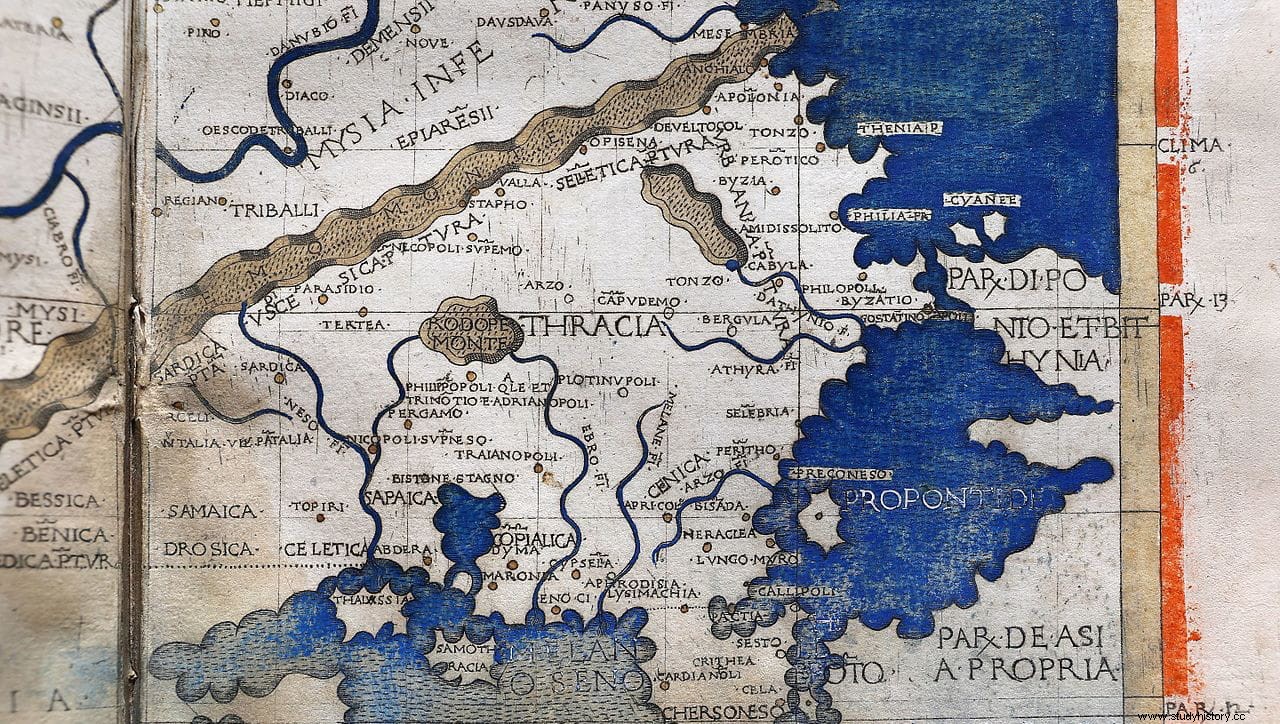
But let's go with the island in question. In Ptolemy's 9th Map of Europe (Nona Europeae Tabula , published in 1467 and kept in the National Library of Poland), as well as many later maps, shows an island located in the Black Sea, at the height of the current city of Rezovo and the border between Bulgaria and Turkey.
It is not a small island, comparatively it could be compared to the current Greek island of Thassos (about 398 square kilometers). The problem is that today there is no island in that location.
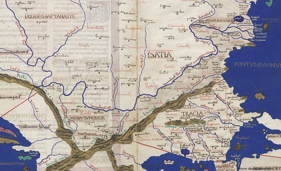
On maps it bears the name of Cyanida (Blue) and in some it takes the form of two islands separated by a small channel. The fact is that after the fifteenth century it completely disappears from the maps and never reappears.
But let's go back to the ancient sources. Herodotus comments in light of Darius's expedition against the Scythians:
And later:
From Herodotus's description it follows that the island (or islands) was the first thing in the path of ships entering the Black Sea from the Bosporus, just as the Ptolemaic maps show.
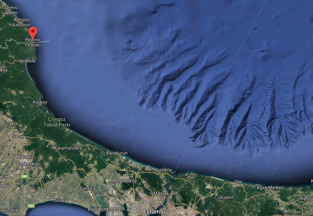
In the early 1980s, a Bulgarian professor of geomorphology and cartography at Sofia University named Dinyo Kanev, who died in 1997, investigated the seabed off the cities of Rezovo (Bulgaria) and Igneada (Turkey). In his study, published in 1982, he assures that there is geomorphic evidence of a submerged or sunken island about 4 or 5 kilometers from the coast: there is a large sandbar with submerged rocks, probably remains of an island destroyed .
Since the island had disappeared from maps at the end of the 15th century, he concluded that it must have sunk about 500 years ago. Furthermore, he suggested that the subsidence could be caused by a combination of tectonic movements and erosion. And it is that in that area of the Black Sea the sea currents circulate from south to north:with the help of earthquakes and landslides, the constant breaking waves gradually destroyed the island of Cyanida according to Kanev.
There is also no lack of identification with the mythical Symplegades, sometimes called Rocas Cyaneas in mythological texts. They are the famous floating rocks that collided with each other randomly, and that the Argonauts manage to cross successfully on their way to Colchis. In the Odyssey they are mentioned by the sorceress Circe as a warning to Odysseus, placing them near the monsters Scylla and Charybdis:
Apollonius of Rhodes also mentions them in his Argonautics , an epic poem written in the 3rd century BC:
In any case, the version of natural collapse would be supported by the evidence of the remains of different ancient cities submerged on the shores of the Black Sea:Byzone, current Kavarna; Accra, near present-day Chernomorets; or Messembria, today Nesebar, among others.