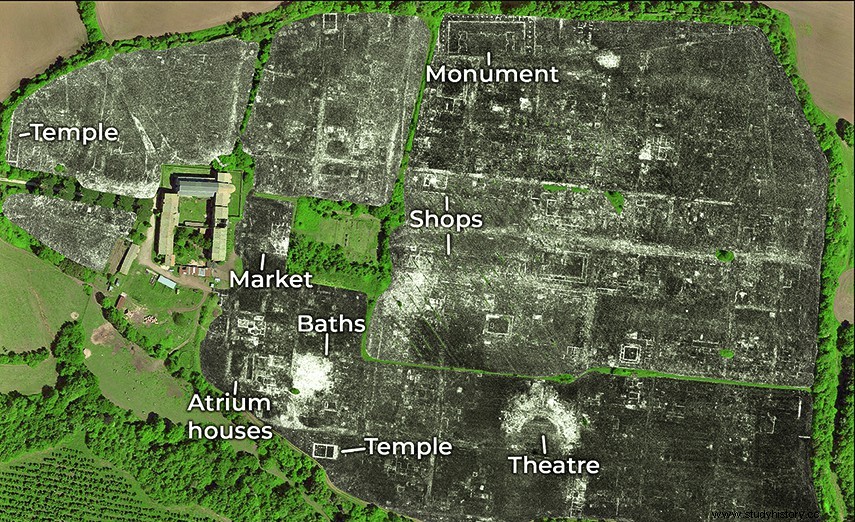
Aerial view of Falerii Novi, near Rome, with the indication of the main buildings identified • AFP Radars are definitely making a spectacular breakthrough in archaeology. In Italy, about fifty kilometers from Rome, without the slightest blow of a pickaxe, an entire city has been mapped using cutting-edge technology that has recently been used:GPR, or ground-penetrating radar. Using an antenna, it sends reflected waves differently depending on the composition of the soil, and allows you to study its structure at different depths and see how it has evolved over the centuries. Thanks to him, we get a fairly accurate map of the city. This is how the streets and buildings of the ancient Falerii Novi became visible, while today only a few ruins emerge:pieces of the surrounding wall and of the theatre, a gate... An original plan This ancient Roman city of 30 hectares was occupied from 240 BC. AD and for the next 700 years. It has been excavated since the 1990s. But, according to the team of scientists from the University of Cambridge, Britain, and Ghent, Belgium, who carried out the study, it is the first time the technology has been used to map an entire city. And the plan of Falerii Novi is much less standardized than that of other Roman cities, such as Pompeii for example. The important buildings, such as the temple, the market or the spa complex, are very elaborate for a small town. Even more surprising:the researchers were able to visualize a large network of water pipes, with pipes that pass under the houses, and not along the streets, as often. The level of detail allowed by this radar is very high, and researchers dream of being able to use it for other ancient cities, such as Cyrene, in Libya. In the meantime, the instrument generates a huge amount of data (about 4.5 GB per hectare) that needs to be analyzed, which will take several months.