Thousands of Mayan ruins have been detected in the Guatemalan jungle using Lidar technology, revealing the unsuspected scale of interconnections between cities.
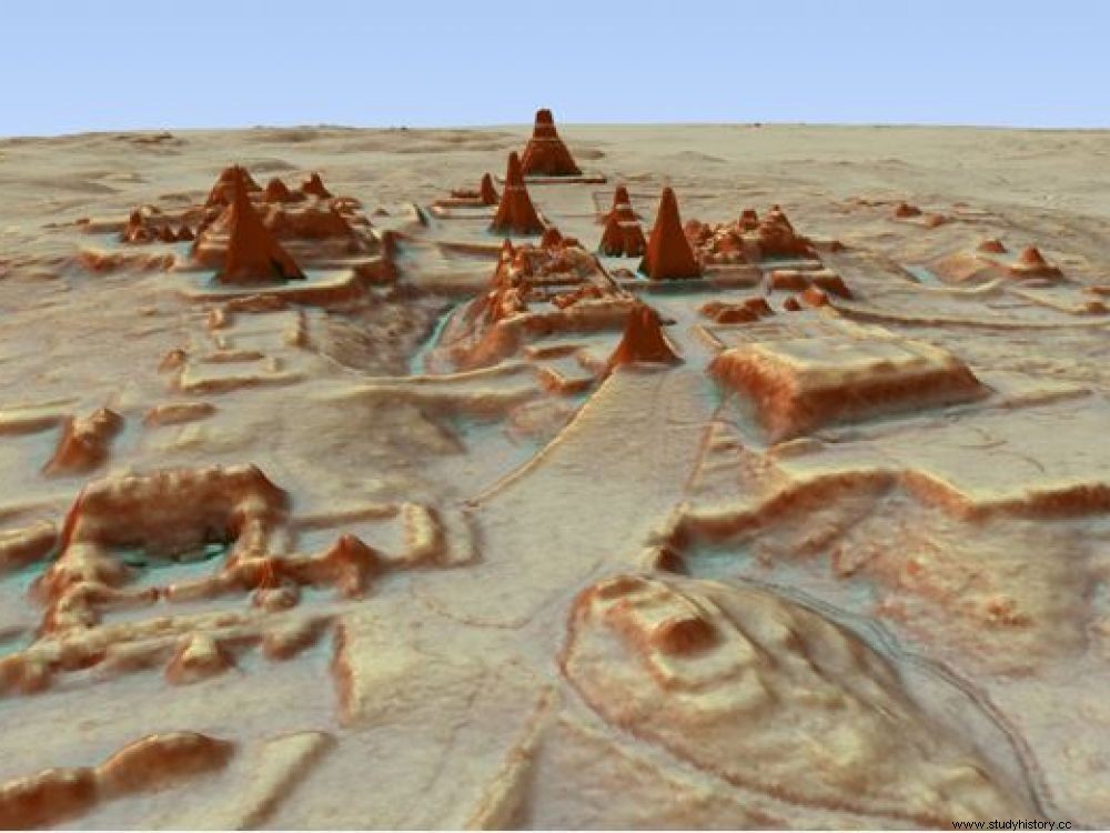
3D rendering of the site of Tikal, where an unknown pyramid was revealed.
"Did we really find a Mayan city of 2,000 km² and 10 million inhabitants? " questions the newspaper Liberation in an article published this Wednesday, February 14, 2018. And to point the finger at the many media victims of a translation error which made them take thousands of Mayan structures for a single and even city. An improbable megalopolis of 2,000 m2 on which Sciences et Avenir had set the record straight on February 5. In case this article has escaped you, we offer it to you again for reading.
The discovery is exceptional. Thousands of unknown Mayan structures and buildings, hidden under the canopy for centuries, have only just been spotted by archaeologists. These large constructions include pyramids, palaces, ceremonial centers, but also less spectacular works such as cultivated plots or dwellings. All are located in the jungle of northern Guatemala, and it is thanks to the use of Lidar (Light Detection And Ranging ), an airborne remote sensing system, that they were spotted as part of a consortium created under the aegis of the PACUNAM Foundation (Patrimonio Cultural y Natural Maya), a non-profit Guatemalan research fund created in 2006. A Franco-Guatemalan project, Naachtun, led by Philippe Nondedeo, is also part of this consortium, and has itself benefited from Lidar coverage over 140 km2 (read box ).
This laser system, coupled with a high-precision GPS, makes it possible to detect all the details on the ground, including under thick forest cover. In particular, it had been successfully used at the Angkor site in Cambodia. All the points recorded during the aerial overflight are then filtered using powerful algorithms to produce a digital model of the terrain via 3D photogrammetric restitutions. The Lidar thus allows a kind of digital virtual deforestation that reveals all the topographic details present over vast areas.
Lidar surveys have revealed that the Mayan city of El Palmar is 40 times larger than previously thought. © PACUNAM
This digital cartography extends here over 2100 km 2 divided into nine sectors north of Péten, in particular in the "Maya biosphere reserve", created in 1990 to protect the largest area of remaining tropical forests in Central America.
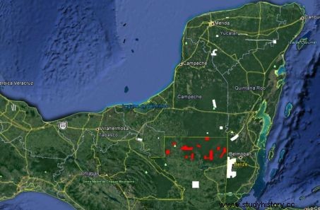
In red, the different archaeological areas flown over by the LiDAR, north of the Péten region (Guatemala):El Zotz, La Corona-Achiotal, Holmul, Naachtun, Uaxactun, Xultun-San Bartolo, Tikal, El Peru- Waka and El Tintal. © PACUNAM
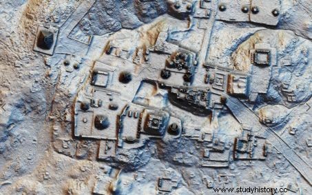
"Lidar is a relatively new airborne remote sensing technology that allows detailed mapping of the earth's surface at a very fine scale. It is far superior to previous forms of satellite or aircraft mapping in that Lidar can penetrate dense vegetation and is ideal for lowland Maya where jungle vegetation prevents traditional mapping" , said Michael E. Smith, specialist in Mesoamerican archeology at the University of Arizona (United States), joined by Sciences et Avenir. Researchers have thus discovered the existence of several urban centers, sophisticated irrigation systems and achievements such as raised roadways that can be used during the rainy season. They were also able to point to more than 60,000 individual structures, ranging from isolated houses to reservoirs and fortifications. A 30m high pyramid -previously identified as a hill- has even been detected in Tikal, yet one of the most studied and visited cities in the Mayan world!
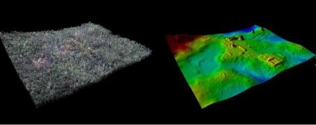
Comparison of two Lidar surveys, on the left, the El Zotz region under forest cover, on the right, the 3D restitution revealing all the details of the ground and the structures present under the forest. ©PACUNAM / Garrison/ Proyecto Arqueologico El Zotz.
"In some cases, known urban centers were found to be 40 times larger than existing maps showed, including several monumental complexes previously thought to be separate sites", explained Francisco-Estrada Belli, from Tulane University, New Orleans (USA), involved in the study where he leads the Holmul* project. One of the most important pieces of information provided by this work remains the unknown interconnection between different Mayan cities, in this region which is well known to archaeologists for its architectural richness, in particular during the so-called classical period (250 to 900 AD). "The Maya Biosphere Reserve" is indeed famous for hosting a high concentration of ancient cities, including Tikal, abandoned in the 10th th century.
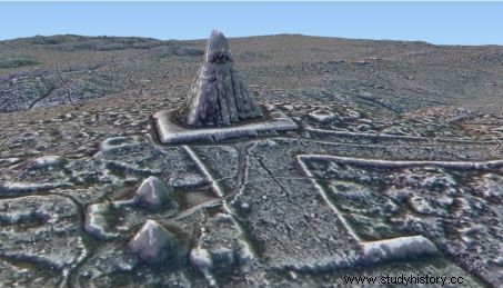
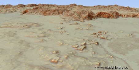
Two other 3D views of Tikal, without forest cover, obtained from analyzes of Lidar surveys. © PACUNAM
"Let's not forget that on each image obtained, there is a millennium and a half of concentrated human occupation! “, recalls Dominique Michelet, director of research emeritus at the Laboratory of Archeology of the Americas (UMR 8096) at the CNRS, involved in the Naachtun project. Also, for him, there is no question of hasty interpretations. 3D to extrapolations on occupation figures by Mayan populations, evoking millions of individuals as we have read, is simply astounding" , continued the archaeologist. This is confirmed, in his own way, by Michael E. Smith:"Lidar will certainly contribute to revolutionizing the study of colonization and demography of the Mayas. But we are only at the preliminary stage to establish nice 3D maps... Not yet to have solid results on the architectures, demography or even the functioning of these societies". We will therefore have to wait for more detailed analyzes to obtain serious estimates of the population. And these steps are only just beginning for the Maya lowlands, where the entire occupation model is now to be reviewed.
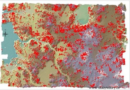
Image of the Lidar coverage of the Naachtun area (140 km2) indicating, with a red dot, each of the 12,000 structures identified. © Naachtun/PACUNAM
The Naachtun Project
"The results of the exploitation of Lidar imagery on the region of Guatemala at the heart of our activities were a real shock" , admits Philippe Nondeneo, director of the Franco-Guatemalan project Naachtun, the name of an important Mayan center located in the Péten region and the basin of El Mirador, which the researcher has been studying since 2011 with Dominique Michelet. In a forthcoming text, the two researchers explain that the results delivered by Lidar technology have extended this territory of investigation to 140 km
2
, or 70 times the study area covered so far. 12,000 structures from all periods have been spotted there! That is an occupation density greater than anything they could imagine. Finally, only the marshy areas would be free of remains. "If we compare these results to all the Mayan sites that were also the subject of this Lidar coverage it appears that Naachtun, in its density of structures, is now comparable to the great Tikal!" .