The form of a "ghost" of modern Greek history, a very important personality, who produced the first Greek maps after 1821, was revealed this morning at the Central Library of the Aristotle University of Thessaloniki (AUTH), as part of the opening of the 130th anniversary map exhibition years of the Army Geographical Service (GYS).
And his name:Alexandros Nikolaou Mavrokordatos. This is not the famous protagonist of the Revolution of 1821, who in Peter von Ess's painting is seen defending Messolonghi holding a map in his right hand. It is about his eponymous grandson, who was born in 1862 and died in 1895, aged just 33. Somewhere in the confusion of the synonymy and among the millions of words that have been written in books and on the internet about the Mavrokordatos of 1821, the story was carefully hidden, which was revealed by the systematic research of the AUTH.

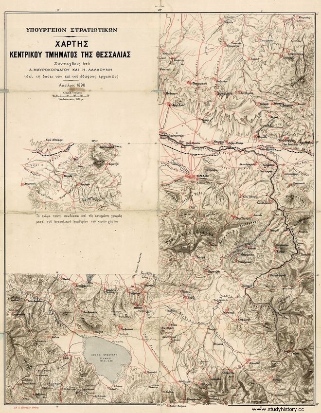
An obituary, a detailed response in a French-language newspaper, a "mausoleum" next to the railway line of Nestos, a tomb in the historical church of Timiou Prodromos of Kavala and an unfortunate war, constituted for the researchers of the Laboratory of Cartography and Geographical Analysis AUTH and the Library &Center Information AUTH the "keys" in the hunt for the treasure of new knowledge, where they arrived with a guide (as an emblematic work and point of reference) one of the most important - based on its contribution to the outcome of historical events - maps, depicting a part of Thessaly:the famous "Map of Mavrokordatus".
The one about whom, after the "unfortunate war", in which the country went without modern maps, the heir to the throne Constantine and vice-general commander of the Army of Thessaly in 1898 in the account says:"The Map, who actually offered service during this campaign, it is the one of the central part of Thessaly prepared under the lieutenant A. Mavrokordatus; this map is very accurate and in its smallest details, easy to read, it is the only one that was used for the formation at Pharsalon, the retreat to Domokon.. .” The heir Constantine, when he led the “unfortunate war” in 1897, was 30 years old and Alexandros Nikolaou Mavrokordatos had died just three years before.
The evidence brought to light by the academic research was presented by the emeritus professor of Advanced Geodesy and Cartography of the AUTH, Evangelos Livieratos, curator of the exhibition entitled "1889-2019:We captured the past, we chart the future" by the BKP-AUTH and the GIS, with the cooperation of MIET-ELIA, inaugurated by the Rector of AUTH, Professor Nikos Papaioannou.
"A mausoleum near Nestos"
On December 26, 1898, in the French-language Journal de Salonique of Thessaloniki, a long response from Komotini, Saadi Levy's own editor, as a special envoy from December 24, is published on its front page.
The response describes, starting from Thessaloniki, his journey by train on the new railway line, which connected the city with Alexandroupoli. This new line - known as Jonction - was built just a few years ago by a Franco-Belgian consortium, to connect Thessaloniki with Istanbul via Alexandroupoli.
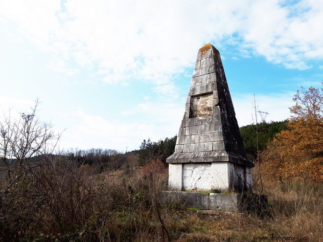
"... Between Nousretli (Nikiphoros) and Buk (Paranesti) we saw the mausoleum of the late engineer Mavrokordatus, the young and fearless head of the department, who succumbed to pain during the construction of the line, who wished to be buried in the fields of honor ..." Levy responded, describing a sight for travelers of the time as it was visible from the train.
"The obituary"
But what was this "mausoleum"? And who was Mavrocordatos, who died by the railway line, when he would have preferred to die on the battlefields? Who was the young engineer with the kind eyes? "The secret was opened by the obituary, which was the central finding", revealed Professor Livieratos, unraveling the tangle of the fascinating discovery.
An anonymous obituary for Alexandros N. Mavrokordatos is published in issue 12 of 1896 of the publication of "Poikili Stoa". "Her text gives some information and answers to the questions that arose from reading the little report in the Journal about the mausoleum of the young engineer who died near Paranesti (Vucion). But not the complete picture for the hitherto "unknown" charismatic cartographer", explained Mr. Livieratos.
Details are also given about the circumstances of his death:"And working there, tirelessly always and forward, they see, in front of topographical maps, mechanical volumes and geographical tables, far from his homeland, his parents, his own, alone in that village the cultured, he found death there, then an uncontrollable and lightning-fast disease".
It is not clear, however, whether his death occurred as a result of an accident at work, or from pathological causes, e.g. due to some hereditary disease, given that four of the seven children of his grandfather, Mavrokordatus of 1821, had died within a year, while his own child also died at the age of six.
"The portrait sketched by AUTH"
As the AUTH research progressed, the questions became rather more:Who was the young engineer Mavrokordatos, who is mentioned with admiration in the response of the Journal de Salonique in 1898? And why a monument to him next to the railway line of Jonction, an obelisk four meters high near Paranesti and Nestos, which the editor of the Thessaloniki magazine even describes as a "mausoleum"? Who was the "trikontoutis" - when he died in 1895 "in Voukios" - Alexandros N. Mavrokordatos, to whom a dense obituary is dedicated in the "Different Lodge" of Athens in 1896?
"We read some of him in his obituary, but not enough of the now almost unknown brilliant young man, whom we find as a second lieutenant in the Infantry, with an interest also in Greek letters -- a member from 1890 of the Revue des études grecques published in Paris the Association pour l'encouragement des études grecques," said Mr. Livieratos, summarizing the information gathered in one paragraph:"Alexandros N. Mavrokordatos was the grandson of the famous homonymous Alexandros N. Mavrokordatos, of the Revolution of 1821, son of of Trieste-born diplomat and politician Nikolaos A. Mavrokordatos. He was born in 1862, probably in Constantinople, when his father was serving there (1858-1865) as a secretary in the Greek embassy. A first cousin of Harilaos Trikoupis, his father was a minister, prefect of Corfu, president of the Association for the Dissemination of Greek Letters, ambassador in Paris and Petroupoli (1882-1889), while then and until 1902 he was the ambassador of Greece in Constantinople, where and diplomatically managed the urgent and difficult affairs of the country, after the unfortunate war of 1897".
"Alexandros", continued the professor, "with military engineering studies in France, married Rallou Mourouzis (1864-1944) at a young age and returned to Greece as perhaps the most scientifically qualified, in engineering projects, officer of the 1880s".
He was commissioned a second lieutenant of Infantry, although he had a European education as a military engineer and taught at the newly formed NCO School. He resigned from the army, just a few years after the establishment of the Geodetic Mission in 1889, where he had been placed with the first officers in 1890. After his return to Greece and his promotion to the rank of Second Lieutenant of Infantry, he was appointed professor at the newly established School NCOs. For the students of the school at the age of 25 he wrote an excellent book of 700 pages, the Military Topography, with examples of exercises and from the German mapping of Attica, the so-called Kaupert. A year later, at the head of a group of worthy infantry second-lieutenants and a second-in-command, he delivers the sheets of the "Map of Mavrokordatos", the first map since 1821 made from scratch exclusively by Greeks and printed in Athens shortly before the arrival of the Austrian expedition for the land registration and mapping of the country.
Regarding the resignation of Alexandros Mavrokordatos from the "Geodetic Detachment" and his inclusion in the force of "Jonction", Mr. Livieratos explained that the historical reasons that led to this decision are not known and "he may have suffered the fate of the children of famous families, who are often not easy to pursue a career when they have this burden of the family - when you have an Alexander Mavrokordatos from the Revolution, who is still persecuted in modern Greek historiography, as all the great ones are persecuted, or a father who saved the lot in the war of 1897".

"The traces of the end in Macedonia"
Alexandros N. Mavrokordatos "bitterly disappointed", according to his obituary, left for Macedonia. He worked there as an engineer in the Franco-Belgian Jonction railway projects, which began in 1893 for the strategic connection between Thessaloniki and Alexandroupolis (the same until today). He died aged 33 near Paranesti on May 7, 1895. The now anonymous marble obelisk (the mausoleum according to the Journal de Salonique) next to the railway line where he worked and the toponym Mavrokordatos, given in 1928 to a nearby settlement, remind us of his cultural engineering work in Macedonia. Today, in the courtyard of the settlement's cultural association, a contemporary smaller obelisk (perhaps) mentally refers to the memory of Alexander's death, while the current few residents, according to oral testimony, "have heard that the name was given to the settlement, to honor a fighter who was killed nearby - probably at an unspecified time." "Obviously the history of the great cartographer is today unknown in the place of his death", said Mr. Livieratos, suggesting that the GYS and the AUTH should place a plaque "so that the marble obelisk constitutes the memory dipole of the cartographer with the "unknown" although his named tomb, which is located in the historical Church of the Holy Forerunner in Kavala".
As the professor explained, Alexander was buried in Kavala, with honors of the powerful Greek Community there, due to its close contacts with his father Nikolaos, ambassador in Constantinople. In the enclosure of the historical church of the Holy Prodromos, the marble tribute is still preserved, donated by his family with the inscription:"The Greek Kavallas Communion in Alexandros N. Mavrokordatou Matioi ».
"AUTH undertakes the beautification and highlighting of the obelisk in Nestos"
"It is particularly moving that in Macedonian land, in Paranesti, Alexandros Mavrokordatos breathed his last, working in peacetime to build the Thessaloniki-Alexandroupoli railway line. We will adopt the obelisk in Nestos and beautify the space, not because we have to do it, we will do it because at Aristotle University we believe that history teaches us and that to be able to see tomorrow it is not only technological achievements, it is also the achievements of the humanities, such as this research that highlighted the obelisk, which we must give special value to, because this is how we honor our history", pointed out the rector of AUTH, opening the exhibition.
"GYS is the oldest cartographic service of the country, with a diverse and remarkable cartographic work. The geographical data it produces are the necessary background, not only for every military operation, but also for the study and planning of infrastructure development projects", said the commander of the GIS, Colonel Vardis Kayadakis, in his greeting. "It is now clear to all of us the power and high symbolism of the Maps. All our major national issues in recent years have always been closely linked to maps", he observed and emphasized the importance of the actions and scientific collaborations of GYS with AUTH, under the auspices of the memorandum of cooperation they signed in 2017.
"AUTH, through the Library and Cartography Laboratory, remembers and honors the Geographical Service, not only to spread the accumulated knowledge, but to fulfill a debt to the founders of this Library, whose purpose in 1927 was to gather maps as "necessary for scientific study and research", emphasized the president of BKP, Professor Ioannis Tzifopoulos. He noted, however, that there is little evidence that a geography service with almost contemporary standards of structure had been organized by the Macedonian kings Philip and Alexander, through the development of corps of pacers and diarists, who were experts in time and topographic measurement of distances, which "is highlighted by Alexander's military successes, which are mainly due to the ideal choice of topography for conducting a battle".
The exhibition is a partnership between the AUTH Library and Information Center and the AUTH Cartography and Geographical Analysis Laboratory, within the framework of the cooperation agreement signed by the country's largest University, Aristotle, and its oldest cartographic organization, the Army Geographical Service. Valuable archival material was contributed to the research and the exhibition by the GIS and the Hellenic Literary and Historical Archive (ELIA) of the National Bank Educational Foundation (MIET).
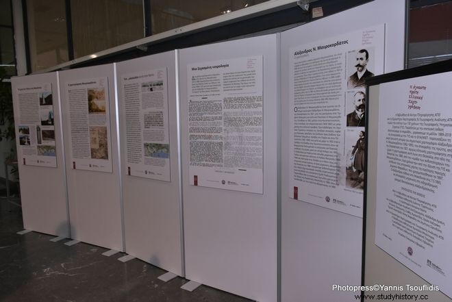
The first part of the exhibition is developed in 52 thematic panels of large size, which are divided into eight chapters, with maps, photographs, explanatory texts, diagrams and digital processing, which were exhibited last October and November at the War Museum of Athens. Interesting, mainly unknown, aspects of the first periods of the life of the GIS and especially of the period after 1897, with the reorganization of the (then) Army Cartographic Service, which led, after close cooperation with the corresponding Austrian one, to the cartographic dimension of the epic are highlighted of the Balkan Wars.
The period of cartographic self-reliance of the Service is presented with emphasis, as it will be manifested with the great, on a European level, geodetic infrastructure and cartographic production in Asia Minor. The exhibition at the AUTH Central Library is complemented by the additional separate thematic section on Alexandros Mavrokordatos, which appears for the first time.
Photo sources:AUTH, GYS, BKP-AUTH, MIET-ELIA, Evangelos Livieratos.