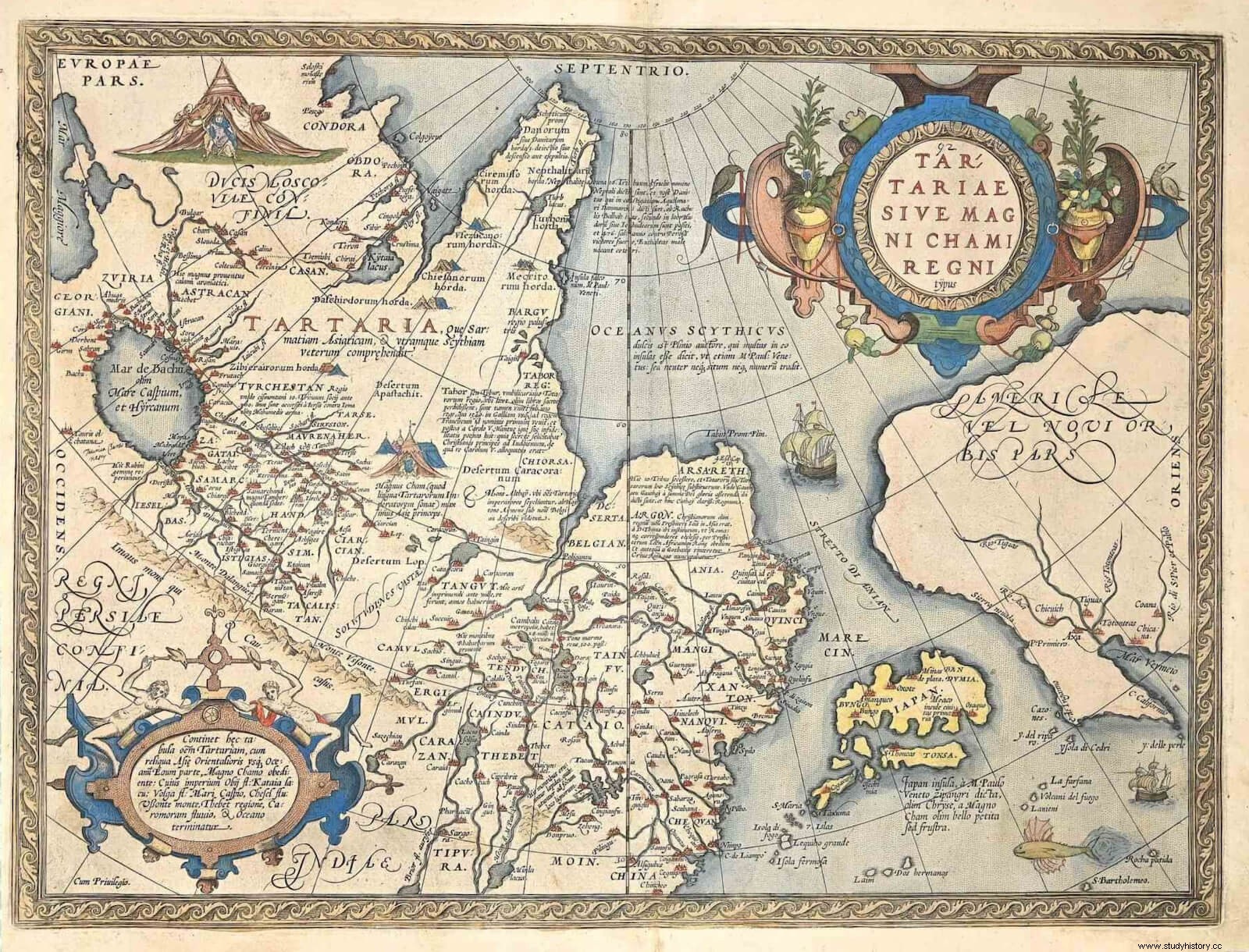
In this sense, in the river basins Volga and Don is where the Flemish cartographer Abraham Ortelius locates Tartary, as we can see on the world map Typus orbis terrarum [1], from 1608, where we also see that Tartary differs from Mongolia itself or from Turkestan. But it can also, in a more generalized way, be used for a larger territorial group, as we can see in maps such as the one by Guillaume de L'Isle:L'Asie [2], published in the year 1700, which reflects a Great Tartary for the vast territory of Central and Northeast Asia, while establishing tartary minors according to political control:the Muscovite, the Chinese and the independent.
This represents how fickle this concept has been in Europe throughout history , until the implementation of Russian rule in the area is completed throughout modern times. The beginning of the diffusion of the term can be located in the Full Middle Ages, which is undoubtedly related to the contemporary expansion of the peoples identified as Tatars, the great Turko-Mongolian nomadic societies [3]. We can attest to this terminological novelty if we go back to the world maps of the time. We observe a clear example from the fifteenth century with the map of Bartolomeo Pareto [4]. If we compare them with immediately previous examples, we notice that it is then that medieval cartography substitutes the term Scythia for that of Tartary, progressively and making them coincide on occasions. We can see Scythia reflected in maps like the Cotton World Map [5], dated to the 11th century, or the Tournai Map Of Asia [6], dated 12th century; both preserved in the British Library . Perhaps the most revealing piece of information in this regard can be seen in the famous Fra Mauro map, drawn up in the mid-15th century. In it, the Italian author clearly locates Tartaria in the area of present-day Ukraine and southern Russia. Of course, difference between Tartaria and European Tartary , being the border of both the Don, thus locating the border of Europe in this river. But in the space of the river Ixartes (modern Syr Daria) clearly writes that the populations there can be referred to as Scythians or Tatars, which gives us the link between the two ethnonyms [7].
It should be remembered that the idea that the medieval West has of this entire area and of the peoples that inhabit it has its origin in classical authors, as it cannot be otherwise form. Herodotus himself dedicates a good part of his book IV of the History to the Scythians. He places them in the plains north of the Black Sea, as well as in an undetermined location further east, in Central Asia [8]. The author makes clear on several occasions the unknown of the northern and northwestern space of the Asian continent [9], clearly pointing out the unknown of those places and the difficulty of obtaining reliable information, which will always be hearsay [10]. He establishes the limit of reliable information in the Argypeans, a people of difficult location that would coexist with the Scythian peoples [11], recognizing the ignorance of geography in the farthest limits of Europe [12].
This line is the one followed throughout the Greco-Roman era. In this regard, as usual, the work of Pliny the Elder It is decisive to understand the formation of the concept of that area that will be handled in the Middle Ages. The Natural History of him , of an encyclopedic nature, was one of the most widespread texts in medieval libraries. In it he makes a description of Scythia that will serve as a reference for cartographers, scholars and travelers. The Latin author places the Scythians in a wide region that goes from the «extreme of the north to the beginning of the summer east» [13], that is, the space that we are observing throughout this text. He also makes clear the ignorance and confusion about the Central Asian space, as well as the mosaic of ethnically different but similar peoples in the eyes of a foreigner, given his nomadic way of life [14].
This will be the framework that medieval explorers will have to face the reality of their travels. They will do it in such a way that they will bring back to Europe first-hand impressions of those lands, which will tell in writing something that until then no one had done. The experiences collected in their stories will be those that contribute to form the concept of medieval Tartary. We will see three of them:Guillermo de Rubruk, Marco Polo and Ruy González de Clavijo . The former is noted for being one of the first to recount his experience and to collect extensive data on the customs and politics of the Mongols. The second, undoubtedly the most famous already in the Middle Ages itself, tried to make a travel guide for merchants, focusing a good part of his story on geographical and commercial aspects. The third stands out, among other things, for being a nobleman on a diplomatic mission, not a religious or a merchant as had been usual, and for showing an incipient humanism.
When dealing with these stories, we must take into account the moment in which the trips are made. The impact of the Mongol states on the Asian scene, born as a result of the conquests of Genghis Khan (1162-1227), was of such magnitude that Europeans needed to know first-hand the scenario of that new reality that had completely shaken the geopolitical board. Some barbarians who came to control one of the three parts of the world, Asia, extending their domain from Europe to the Ocean Sea at its easternmost end, including the legendary Cathay (China). This makes the Khan the most powerful ruler of the time and his court the most politically important place on a global level . For this reason, many monarchs and popes decide to send diplomatic embassies with similar motivations and objectives, such as diplomacy and espionage, usually hand in hand.
It is also essential to understand the moment in which Christian Europe finds itself, a Europe of the 13th century that reached a remarkable maturity with the rise of the great monarchies, the culmination of a demographic takeoff that had not been seen since Roman times, and certainly not seen before in the north of the continent; the rise of a new urban way of life, with its craftsmanship, its characteristic nobility or the emergence of proud Gothic art; the stabilization and expansion of the Christian space or the irruption of the mendicant orders, which shake the ecclesiastical panorama; the reception of Aristotelian philosophy, which meant the return of experience as the basis for the construction of knowledge; It was that Europe that tried to send specialized profiles to get to know that world, to dispel the imagined nebula that Scythia or Tartary supposed until then, turning these missions into a matter of State [15].
European travelers to Tartary
The three authors that we will see as an example did not travel exactly the same spaces, although they could coincide in several of them. However, they all mention Tartaria as the place where this people lives, the land of the Tartars. Their texts have in common the profuse description of the reality of the Turko-Mongolian peoples. It is common to all of them to describe the settlements, the material culture, the semi-nomadic way of life, the forms of family and strange customs for European Christians, what they ate, their relationship with cattle, both bovine and equine, as well as as its special link with equestrian culture, the basis of social and military relations.
William of Rubruk He was one of the first travelers to leave a written record of his journey, which took place between 1253 and 1255. As a missionary, but in possession of letters from King Louis IX of France as if he were a diplomat, he toured the steppe of Asia Central from Constantinople to Karakorum, where he visited the court of Möngke Khan, grandson of Genghis Khan. He talks about the customs of the Mongols, for example about the way they feed themselves, both what they eat (highlights the description of the c omos , drink made with mare's milk) as the way to do it, that is, the social ritual [16]. He thoroughly describes aspects such as gender roles or burial rituals [17]. Precisely in all these descriptions, the importance of livestock for those Mongol populations of the mid-13th century can be observed, as well as the itinerant way of life so closely related to this activity. In the capital, Karakorum, in addition to the city, he describes the palace as a church as far as architectural layout is concerned. He speaks of various Europeans as court figures surely doing diplomatic work, as well as prisoners of war from the Horde's campaigns in Europe, of Hungarian or Russian origin [18].
The story of Polo It is undoubtedly the most famous of the three to which we are going to refer. It already was in his time, a real success in diffusion [19]. In his travels, the Italian merchant will cross Central Asia and even enter Mongolia. In addition to referring to the distances, itineraries and products present for trade in each place, Polo abundantly describes both landscapes and customs of the peoples he encounters, showing the melting pot of cultures that the Silk Road represents. In Tangut and Campçio he details Buddhist rituals [20], in Lop he speaks of his desert, full of dangers and anguish , like the spirits that seek to mislead travelers [21], in Camul he narrates what is clearly an example of ritual prostitution [22]. In Mongolia itself, he briefly describes Karakorum, the first Chinggisid capital [23], as well as the original region of the Tatar people, the Bargú plain, whose inhabitants live semi-nomadly in the Mongolian style:they behave like Tatars [24]. He explains that the descendants of Genghis Khan are buried in the Altai massif [25] and summarizes the Mongolian religion [26]. All this information will penetrate deeply into the European literate environments and will be taken into account as a reference as we can see if we return to the map of Fra Mauro.
Pin brings a much more human view of his journey. In it, for example, we can see the difficulties he suffered on the itinerary that took him to Samarkand, showing that traveling at that time was a tough adventure, full of hardships. At its time, the early 15th century, the Timurid Empire was undoubtedly the leading state in Central Asia and the Persian realm. During the previous century, the Genghisid empire had given way to smaller entities that were fighting for power, a struggle in which Timur had managed to build a powerful state with its capital in Samarkand. On his trip to this city, Clavijo crosses the Khorasán, spends the night in the tents of the Chacatais [27] (name of Chagatai Khan, the son of Genghis who received this area as an inheritance) that he meets along the way and enters the Land of Tartaria crossing the Amur Darya river (which he calls Viadme ), which he also calls Land of the Empire of Samarcante as opposed to Horazania , Khorasan[28]. Throughout the story he describes the customs of this Mongolian group, whose membership would be a reason for prestige, while giving details about flora, crops or ways of eating. In addition, of course, he describes the population centers of that region, especially Samarkand [29]. Speaking of the war between Timur and Toqtamish, Khan of the Golden Horde, the latter is called Emperor of Tartary [30] and, when he must leave Samarkand, he relates that he does so by returning to Tartary , referring to that space bathed by the Volga and the Don[31]. Clavijo's story thus gives us another example of the variable notion of Tartary, the common element being its location north of the traditional territories of the Anatolian, Persian and Indian spheres and its status as a land inhabited by Tartars. This space coincides with what tradition had been calling Scythia.
Although the three travelers have different itineraries, the three converge in the same mental space of great symbolic importance, the emperor's court. The Europeans will be able to see through the narrators how the court dynamics are, from luxuries and banquets, to trade in privileges and diplomatic struggles, through the dangers of the spheres of power. In this regard, the facts and events can be especially vivid, as happens to Clavijo when he is informed that Timur is close to death and that he must leave Samarkand as soon as possible due to the political instability that may arise [32 ].
In short, narratives such as those of Rubruk, Polo and Clavijo, but also those of many others, represent a channel of communication and dissemination of the reality of the Tatar peoples precisely in their moment of expansion. Through them in Europe a new image of that vast extension and its populations will be received that will modify the existing idea until then, which moved fully on the plane of fantasy and superstition. It was through these authors that that fabulous world became more real and better understood. When that immense expanse of land ceased to be a merely imagined place to be a known place and, most importantly, reported , was when it stopped being called Scythia to be called Tartary.
Bibliography
- Cunliffe, B. (2019) Ocean. A history of connectivity between the Mediterranean and the Atlantic from prehistory to the 16th century . Wake up Ferro Editions, Madrid.
- Gadrat-Ouerfelli, G. (2015). "Marco Polo and the Million Book", in Archeology &History #29 Marco Polo and the Silk Road Wake up Ferro Editions. Madrid.
- Gil, J. (1993) In demand of the Great Khan. Travel to Mongolia in the 13th century . Alliance, Madrid.
- González de Clavijo, R. Embassy to Tamerlán . Miraguano editions. Madrid, 2016.
- Morgan, D. (1990) The Mongols . Publishing alliance, Madrid.
- VVAA (2016):Old Maps of the World . Editorial Libsa. Madrid.
Classical and medieval fonts. Information and links to maps
- Herodotus, History . Gredos. Madrid, 2008.
- Polo, M. Travel . Akal, Madrid, 1998.
- Pliny, Natural History . Gredos. Madrid, 1999.
- Cotton Map (British Library MS Cotton Tiberius B v, f. 56v).
- Tournai Map of Asia (British Library Add. MS 100049, f. 64r).
- Fra Mauro, world map:https://engineeringhistoricalmemory.com/FraMauro.php
Notes
[1] Ortelius Abraham (1608):Typus orbis terrarum. Ancient maps of the world, plate 9. Editorial Libsa. Madrid, 2016.
[2] L´Isle, Guillaume de (1700):L´Asie:dresée sur les observations de l´Academie Royale des Sciences . Ancient maps of the world, plate 29. Editorial Libsa. Madrid, 2016.
[3] For an explanation of Central Asian nomadic society prior to the rise of Genghis Khan, see Morgan, D. (1990) The Mongols . Publishing Alliance, Madrid. Page 53 et seq.
[4] Cunliffe, B. (2019) Ocean. A history of connectivity between the Mediterranean and the Atlantic from prehistory to the 16th century . Wake up Ferro Editions, Madrid. Page 32-33.
[5]Cotton Map (British Library MS Cotton Tiberius B v, f. 56v) . The original document is digitized and can be consulted on the British Library website. For a more interactive consultation, you can visit the following link:https://sims2.digitalmappa.org/36
[6] Tournai Map of Asia (British Library Add. MS 100049, f. 64r). Like the previous one, the digitized document is available to the public on the British Library website. There is also an interactive version at:https://sims2.digitalmappa.org/36
[7] A digitized edition of the map can be found at https://engineeringhistoricalmemory.com/FraMauro.php
[8] Herodotus, History , Book IV 16-21. Gredos. Madrid, 2008. Page 296 and following. Specifically, it identifies as Scythians the populations settled in the territory between the Danube and the Don. Occurrence in a more eastern part, separate from the main group, is listed in ibid . IV, 22 p. 301.
[9] Space that, by the way, for Herodotus is part of Europe and not of Asia proper, whose northern border is located between the Black Sea and the northern course of the Indus . For the northern limits of Herodotus' Asia, see ibid . IV 37-40. For his conception of the extension of Europe, see ibid. IV 42, p. 317 and following.
[10] Herodotus, ibid . IV, 16, p. 296.
[11] Even the Argipeans, I repeat, the terrain is known; however, no one knows how to speak knowingly about what lies beyond . Herodotus, ibid , IV, pp. 21-25, 300 and following.
[12] As far as Europe is concerned, it is clear that no one knows whether it is surrounded by water to the east and north , Herodotus, ibid , IV 45 p. 326.
[13] Pliny, Natural History , book VI 34. Gredos. Madrid, 1999. Page 296.
[14] Pliny, ibid Book VI 51. Page 312.
[15] See Morgan, D. (1990) op, cit . Page 207 et seq. The author details the diplomatic missions sent to the different khans throughout the Three Hundred.
[16] Gil, J. (1993) In demand of the Great Khan. Travel to Mongolia in the 13th century . Alliance, Madrid. Page 296 and following.
[17] Gil, J. (1993) ibid . Page 304 and following.
[18] Gil, J. (1993) ibid . Page 392 and following.
[19] For the impact of Polo's work in Europe at the time, see Gadrat-Ouerfelli's article Marco Polo and the Million Book , in Archeology &History nº 29, Wake up Ferro editions. Madrid. 2015.
[20] Polo, M. (1998):Travel . Akal, Madrid. Page 123 and following for Tangut and 133 and following for Campçio.
[21] Polo, M. (1998):ibid . Page 120 et seq.
[22] Polo, M. (1998):ibid . Page 126 et seq.
[23] Polo, M. (1998):ibid . Page 136-137.
[24] Polo, M. (1998):ibid . Page 153 et seq.
[25] Polo, M. (1998):ibid . Page 143-144.
[26] Polo, M. (1998):ibid . Page 146.
[27] González de Clavijo, R. (2016) Embassy to Tamerlán. Miraguano editions. Madrid. Page 153.
[28] González de Clavijo, R. (2016) ibid . Page 158 et seq.
[29] González de Clavijo, R. (2016) ibid . Page 218 et seq.
[30] González de Clavijo, R. (2016) ibid . Page 225 et seq.
[31] González de Clavijo, R. (2016) ibid . Page 229 et seq.
[32] González de Clavijo, R. (2016) ibid . Page 216-217.