Ancient and Medieval Wake Up Ferro It is already reaching its fifty number, fifty numbers and eight years of adventure, of running along the paths of our past, now narrow like mountain trails, now wide avenues like the Via Appia when it approaches Rome. This is a journey in which we draw the map as we go, like explorers of yesteryear, planting milestones that would collide on a traditional chart, like the crossing of the desert that were our first years, the mountains to climb with each of the new headwaters or the forts that are our offices, their walls built with books and more books, behind which we wait for the barbarians with the relentless reinforcement of our readers. As they know, cartography is a fundamental part of Desperta Ferro, which is why we wanted to celebrate this anniversary by giving away an 84×59 cm map of the Roman world , based on the famous Tabula Peutingerian, which comes directly from the scriptorium of Carlos de la Rocha, our teacher of portolans and world maps.
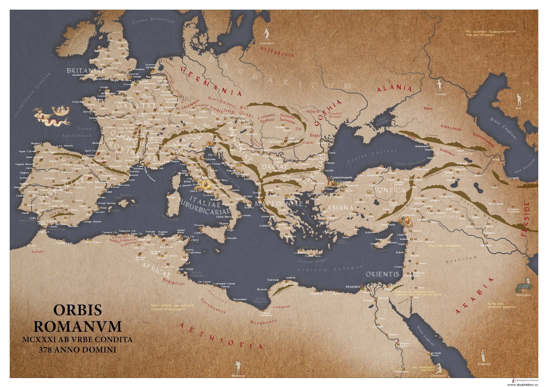
ORBIS ROMANVM – MCXXXI AB VRBE CONDITA is a map of the Roman world in the year of the battle of Adrianople, 378 anno domini , or 1131 according to the Roman calendar, which counted the years from the founding of Rome in 753 BC. C. For its preparation we have used a current geographical base, but the aesthetic inspiration and a good part of its content come from what is known as the Peutinger Tabula or Peutingerian Tabula , Codex Vindobonensis 324, kept in the Austrian National Library, Vienna. The Tabula Peutingerian reproduce a world map or an itinerarium pictum Roman, on a very long and narrow parchment roll, 675 by 34 cm, which was divided into segments to facilitate its conservation, of which only eleven are currently preserved. Although its elaboration has traditionally been attributed to a Dominican monk from the Colmar convent in Alsace, where we know that a world map was made on twelve parchment pages in 1265, paleographic studies suggest an earlier date, from the 12th century or the beginning of the 13th century. . Indeed, in the Tabula Peutingerian Carolingian calligraphy is used – in use between 800 and 1200 – and not the Gothic minuscule typical of the 13th century. In any case, its place of manufacture does seem to have been some monastery in Swabia or Germany, the current southwest of Germany or northern Switzerland, as the mention and drawing of the silva Marciana would indicate. –the Black Forest– and the silva Vosagos –the Vosges–, the only forests reflected in the Tabula. The same would indicate the place names France, Suevia, Alamannia, which are the only ones assigned to barbarian peoples, while others are identified with the ethnonym, not with a region.

The name of the Tabula Peutingerian It comes from the German humanist Conrad Peutinger, who in 1508 inherited the document from Conrad Celtes, librarian to Emperor Maximilian I, although we do not know where he found it, although the Reichenau monastery, on an island on Lake Constance, has been suggested. Peutinger amassed a large collection of books, and to his credit is the first collection of Roman inscriptions (Inscriptiones Romanae ) and the first impressions of Gethics of Jordanes and the Historia Langobardorum by Paul Deacon. The first publication of the Tabula Peutingerian it had to wait until 1598, by Markus Welser, a relative of the Peutinger family.
The Tabula Peutingerian :the only Roman world map that has come down to us
The Roman prototype of the Tabula Peutingerian it would be a world map or an itinerarium pictum made between the years 335 and 366, although this is a point subject to debate. This dating is suggested by the importance of three cities on the map, Rome, Constantinople and Antioch, the only ones with three personifications, and which are also illustrated with famous monuments:in the case of Rome , a section of the Via Triumphalis that led to San Pedro; in that of Constantinople , the column of Constantine; and in that of Antioch , the temple of Apollo at Daphne and the spring from him. The construction of Saint Peter began between 326 and 333, Constantinople was founded as a second Rome in 330, on the site of ancient Byzantium, while Antioch became the axis of the Roman East from the middle of the fourth century, a bastion against Persia. Sassanian The Temple of Apollo at Antioch was burned in 362, which could indicate a terminus ante quem for the preparation of the prototype of the Tabula . But things are not so simple, since perhaps the Antiochene building on the map is another, and not that temple. Nor are there excessive Christian references, and those that do exist, such as St. Peter's Basilica or the allusion to the forty days that the Israelites wandered with Moses through Sinai, could be additions by medieval copyists and not be in the original. This scarcity of biblical references seems key to us in the face of the little accepted theory that the Tabula Peutingerian It is actually a map made in Carolingian times based on Roman itineraries, in line with Charlemagne's claim to the Empire and his enthronement in Rome.
In fact, the analysis of the place names of the Table Peutingerian indicates that we are dealing with a document that mixes data from different periods. Thus, place names are those that were commonly used before the time of Diocletian and the Tetrarchy (293-305), with the exception of Constantinople, which would relate it to the Antonine Itinerary , a document from the time of Caracalla (reg. 211-217) that collects the roads of the Roman Empire. However, there are also places that no longer existed in the third century, such as Herculaneum or Pompeii, destroyed by the eruption of Vesuvius in the year 79. The relationship with a road itinerary seems evident, given that the network of toponyms of the Table fit together like stages on a travel route, rather than simply marking locations. The same indicates that the names of places do not appear in the nominative, as for example in the Geography of Ptolemy, but in a plurality of cases –accusative, ablative, locative–, as if they were elements of a sentence that read “from here to here X miles”.
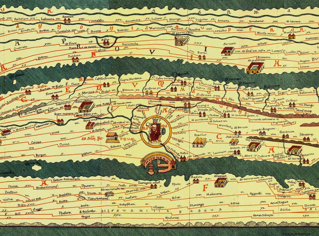
The Tabula Peutingeriana it is therefore a road map , in which the main roads are drawn in red, using straight lines, totaling about 70,000 Roman miles, which is 104,000 km. The distances between places are usually indicated on the map, usually using the Roman mile, although for Gaul the Gallic league is used, for Persia the parasang and for India – which we have left out of our map – the Indian mile. The proportions of the Tabula – 675 cm long by 34 cm wide– they cause east-west distances to be represented on a much larger scale than north-south distances. This is because the map was probably made on a papyrus roll, which was transported in a circular box –capsa –, which limited its width but not its length. It has also been suggested that the original map may have decorated the apse of the basilica of Diocletian's Palace in Spoleto, based on the measurements of the apse –7m– and the layout of Rome in the center of the map.
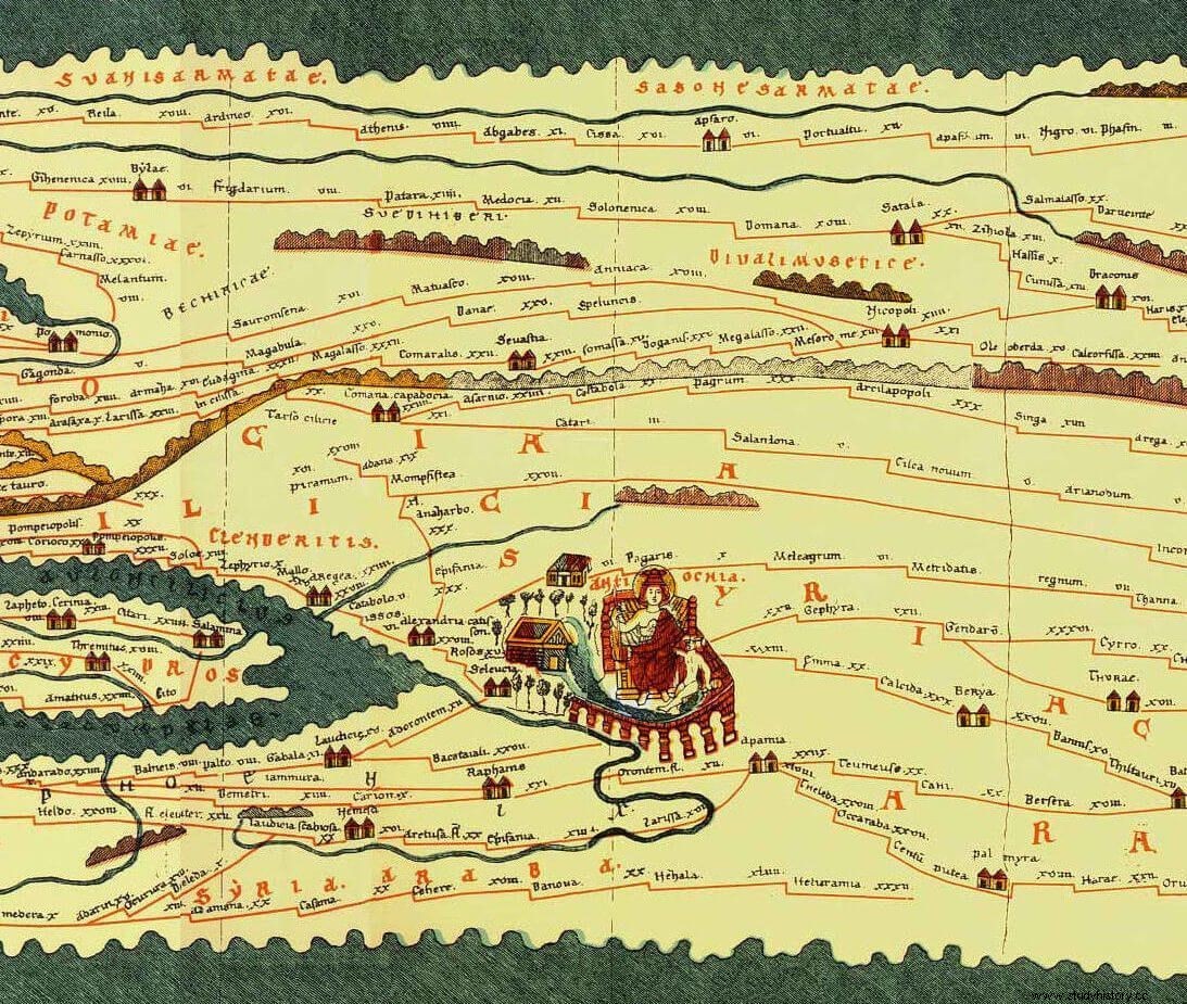
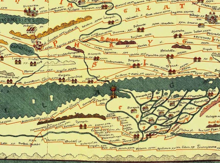
As we have mentioned, eleven fragments from the Tabula Peutingeriana , since it begins on its first sheet with a fragment from southeastern Britannia, the eastern part of the Pyrenees, part of Gaul, North Africa, and Corsica and Sardinia. The previous sheet, which would have represented the missing parts of Britannia, Hispania and Africa, would have already been lost when the medieval copy was made. Here we have followed the reconstruction that Miller carried out in 1898 of that segment based on the Antonine Itinerary . Some authors think that Rome would have occupied a central role in the Tabula , so in that case it would be necessary to think of three more segments in the western part, now lost. Gaul and Africa continue in the second segment, and Germania appears in the upper area. In the third, the Alps and transalpine Gaul are shown, with Africa to the south, while the fourth is devoted to central Italy, with Rome as the center to which all roads arrive, in a twelve-way radial network with their respective labels:Appian Way , Latrine , Labicana , etc. Rome is represented by a crowned man seated on a throne, with a center and orb in his hands. The fifth segment includes central and southern Italy, with Mesia to the north and Africa to the south. In the sixth segment appear the boot of the Italian peninsula, Sicily and Greece. In the next segment Greece continues and Crete and Cyrenaica appear to the south, while in the eighth Constantinople, Anatolia and the Nile delta are shown. Constantinople is personified in a woman on a throne, perhaps the Tyche –Fortune– of the city . The ninth segment is dedicated to Palestine, Antioch and Cyprus, and the tenth to Mesopotamia, while the last reflects the Caspian Sea, India and, in the lower right corner, the island of Taprobana, the ancient name of Ceylon. At this end of the world, the Tabula Peutingerian points to the place where Alexander found in an oracle the answer to his inextinguishable desire to always go forward: Hic Alexander responsum accepit:Usq (ue) quo Alexander .
Cartographic icons and toponymy
In addition to routes and distances, the Tabula Peutingeriana it shows cities, ports, lighthouses, altars, silos, thermal baths, post stations, lighthouses, rivers, and mountain ranges, employing a plethora of cartographic icons to mark these landmarks. Mountain ranges are marked in light brown and rivers, lakes and seas in green, and we have already mentioned the personifications of Rome, Constantinople and Antioch. Among the ports, that of Ostia stands out, with a profile that recalls the hexagonal design of Apollodorus of Damascus, as commissioned by Trajan and which we know from the coinage of this emperor. Among the lighthouses, highlight the Brigantia, the still standing Tower of Hercules in La Coruña, and the famous Lighthouse of Alexandria, the "lighthouse" par excellence.
The bathrooms –aquae– they are represented as a square building with a courtyard, and sometimes with two towers, as for example in Aquis Sestis, today's Aix-en-Provence. The silos –horrea – they are marked as rectangular buildings with gabled roofs, and it is an important symbol if we take into account the possible military uses of a map like this, according to what Vegetius says in his De re militari III.6.4 (trans. D. Paniagua, Ed. Cátedra):
Most of the settlements are only marked on the map with the name, but the most important ones are also distinguished with an icon. There is a great variety of these and there does not seem to be a uniform criterion. Thus, there are some important cities that are drawn walled, such as Aquilea, Ravenna, Thessaloniki, Nicaea or Nicomedia, and others such as Alexandria or Carthage are not. In fact, it is strange that these two important cities do not have a symbolic representation. The most modest are marked with a kind of two "little houses" together, as in Tarracone or Corduba, and sometimes walled, as Mogontiaco, in the limes Rhenish.
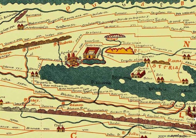
As we have already indicated, place names in the Table Peutingerian they correspond to different times, and if we add to that that they do not appear named in the nominative and we superimpose the medieval transcription on it, we find that many place names do not exactly agree with the classical name that we would expect. Case for example of Barcino, the current Barcelona, which in the Tabula is Barcenone, or Cartago, which appears as Cartagine col., that is, the colony of Cartago. And don't forget that in the scriptoria medieval to his own Titivillus, the demon of spelling errors; for example, the copyist of the Peutingeriana he was wrong to transcribe the river Liger – the Loire – as Riger, something that a later copyist corrected by adding a capital L to the name. Titivillus is also a good friend of Master de la Rocha, so we ask for your indulgence if this mischievous little devil makes a small mistake on this or any other of his maps.
Our elaboration and our licenses
When making our ORBIS ROMANVM – MCXXXI AB VRBE CONDITA, map of the Roman orb around the year 378, we did not want to make a simple copy of the Tabula Peutingeriana , which would also have been impracticable due to its great length, almost seven meters! Instead, we have chosen to draw a geographical basis for Europe and the Mediterranean according to current knowledge, but keeping the style of the Tabula , so you'll see a literal with thick, undefined outlines. On this basis we have chosen among the plethora of toponyms collected in the original to keep only the most relevant places, since at the scale on which we have worked it would be impossible to include them all. For each of them, the cartographic icon used in the Tabula Peutingeriana has been placed. . As we pointed out a little above, you will see that many toponyms do not correspond to their classic form, but we wanted to leave them that way to be more faithful to the original. We have also synthesized the road network, drawing the most outstanding roads in red, and that already show the very dense network of communications that ran through all the provinces of the Empire. In the ORBIS ROMANVM we have also had to dispense with the distance indications between the different points that the Tabula Peutingeriana collects. , since we have not included many places, which serve as stages, and also because it would be too crowded. But if you are curious to know this information, as well as the days it would take to travel between two places in the Roman world, we recommend that you take a look at the magnificent page Omnes Viae , which also contains a digital copy of the Tabula at high resolution.

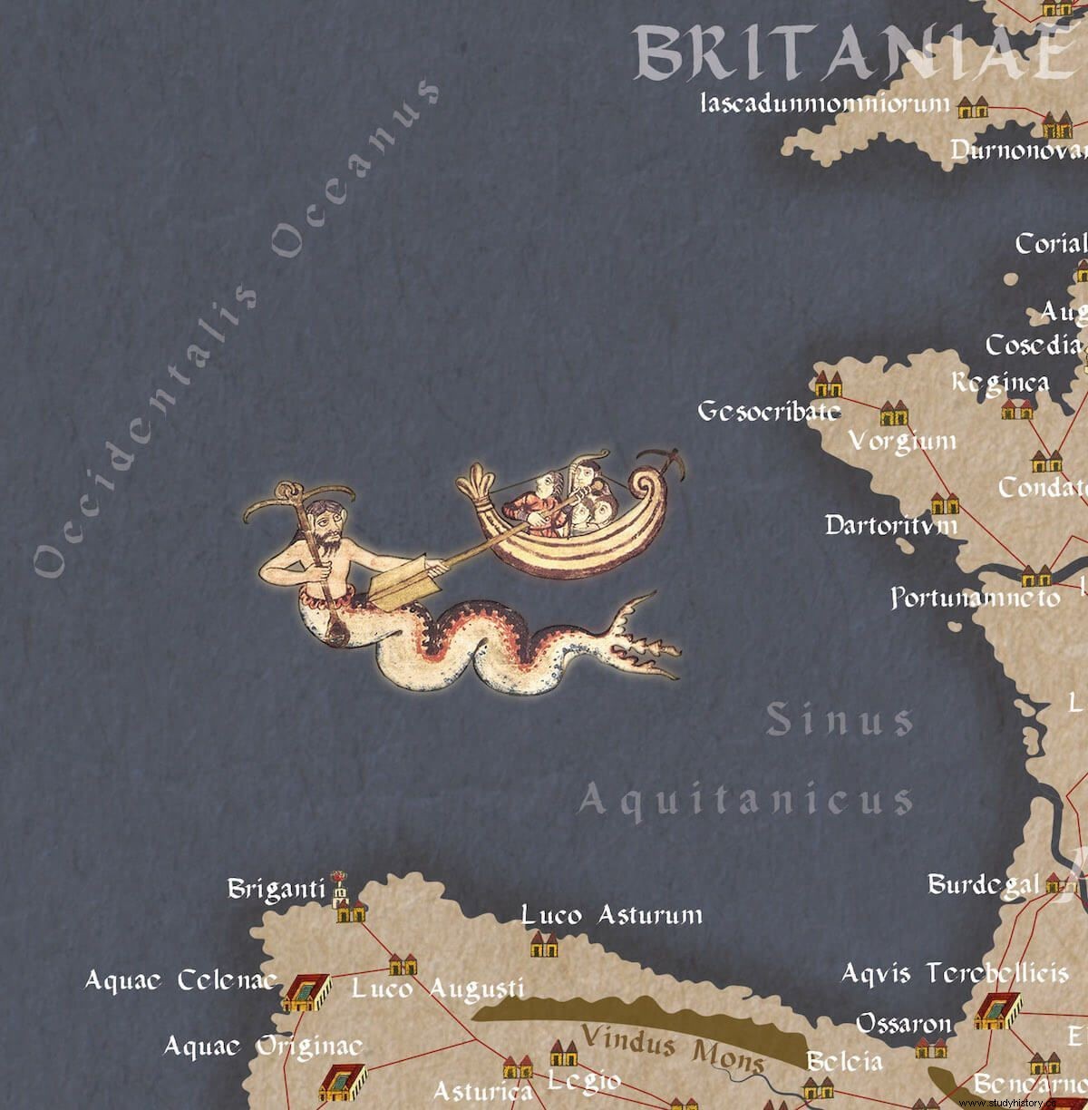
In the Peutingerian Tabula some didascalia appear , those clarifications or annotations so typical of medieval maps. We have kept those that we have found most curious, such as the one that indicates the place where the cynocephalians are born (Hic cinocepahli nascuntur ) or the one that marks the border between Rome and Persia in the Arabian desert. Others, which in the original appear in segments not included in our map, we have moved them to be able to include them; it is the case of the place where the serpents are born (In his locis serpentes nascuntur ) or from the oracle to Alexander, which we have placed on the borders where Europe and Asia meet. In addition to those cynocephalians that the Tabula located on the coast of the Sinus Arabicus, the current Red Sea, we have added to our ORBIS ROMANVM some of the monstrous races collected by classical geographers:the blemmies, the sciapods, the manticore, the nulli, the arimapos or the hyperboreans. To represent them we have taken miniatures from the manuscript MS. Ludwig XV 4, preserved in the Getty Museum and which includes works on a diverse subject –De Natura Avium, De Pastoribus et Ovibus, Bestiarium, Mirabilia Mundi y Philosophia Mundi–. The folios 117r to 120r of the manuscript collect some monstrous races, and drink from the Natural History from Pliny the Elder and from the Physiologus , an anonymous Alexandrian written around 400 and that collects descriptions of beasts and fantastic creatures in a moralizing key. These miniatures were made between 1280 and 1300 in a monastery in the north of France, perhaps Saint-Omer, and their style and period are not at odds with that of the Tabula Peutingeriana . Another license we have allowed ourselves is the inclusion of a sea monster, a merman, struggling with a ship, a miniature that comes from folio-117v of theStuttgart Psalter , a Carolingian illuminated manuscript from around 830. According to Pliny (Nat. Hist . IX.9), an embassy from Olisipo –Lisbon– informed the emperor Tiberius that a triton had been seen, which was making a shell sound in a cave, and who are we to contradict that wise man.
If a map is a graphic representation of a conception mental, the projection of an idea of the world, the ORBIS ROMANVM shows how it was seen by a 4th century Roman. An oikumene , an ordered world, known and communicated around the Mediterranean, on whose edges others threaten, be they ululating barbarians, be they dog-headed cynocephalians and cannibalistic habits. The monster, always lurking beyond the border…